23-7-02 (Tuesday)
 I couldn't get up; it was so nice to lay in. But eventually I had to make a move and march on, up and up the valley. Because Jim wanted to carry the gun I had to take the whole tent which weighed us down considerably.
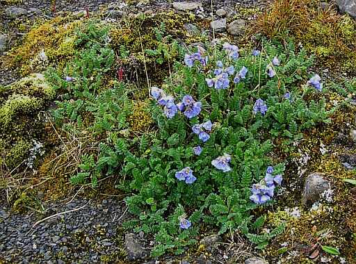
I took some time out to the study of the Svalbard flora. One of the lovely flowing plants is the one shown, the Boreal Jacob's Ladder (Polemonium boreale Adams)
I couldn't get up; it was so nice to lay in. But eventually I had to make a move and march on, up and up the valley. Because Jim wanted to carry the gun I had to take the whole tent which weighed us down considerably.
I took some time out to the study of the Svalbard flora. One of the lovely flowing plants is the one shown, the Boreal Jacob's Ladder (Polemonium boreale Adams)
The going was tough; we had loose rocks, we had mud and in general uneven ground; slogging on and on we managed 6.5km. At the point where we thought that we should cross the river we couldn't. It is far too steep along the sides, loose rocks and the river being compressed into a single channel was flowing deep and at a rapid rate. Certainly not very inviting for crossing.
Fortunately some fellow hikers came from above and informed us about what is to be done. Carry on along the left side and you will find an easy place to cross.
24-7-02 (Wednesday)
What a trip. Jim still tried to get us down some steep slope and up again, just as steep on the other side on one of those slab-slopes. Irene and I refused. Carrying on we soon found the passable place. As expected the water was ice cold, but the crossing was quick. And then we went up and up over muddy terrain, up a snow bank or two, across snowed over rivers and than we got lost.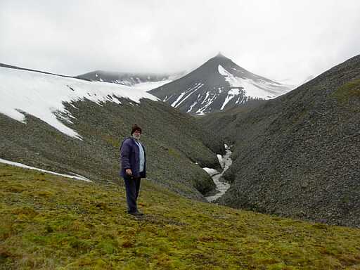 Well, not totally lost, we knew we were on Svalbard but we couldn't find our way to Grumant-dalen. The Russians used to have a coal mine there. Not getting there would not have been a disaster, we knew if we carry on going south we would get to Colesbukta. But Grumantdalen was an interesting place; we wanted to get there. Being in misty conditions didn't help much with orienteering. Irene suggested using the GPS. Yes, why hadn't I thought of that? Jim was sceptical and I roughly estimated a point in the valley and entered it into the memory. And away we went following the arrow in the display. Soon we got to a bit of a road that showed that we were on the right track. Soon after that we looked down into the valley. The sides were fairly steep but a snow bank invited to an easy descent. Footprints in the snow showed that somebody had come up this way. Irene refused and actually turned around to get back the way we came. Jim at that stage had already gone down and came charging up and ran after her. He managed to convince her that with two ropes tied to her we will get her down safely. And that we did.
From the bottom of the snow it went down and down into the valley. Clearing the mist we had a beautiful view over the bay and over to the glaciers of the other side. Near the water's edge were the remnants of the Russian operation: workshops, stores, quarters, and offices. No clean up was done when the Russians left, old rusting equipment everywhere. Near the top we found a reindeer skeleton, cause of death: entanglement in some wire rope that had been left lying around. 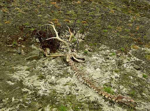
Having a good look around the buildings we decided to take up lodging in one of them. It looks like it was some offices; we made it into a lounge and two bedrooms.
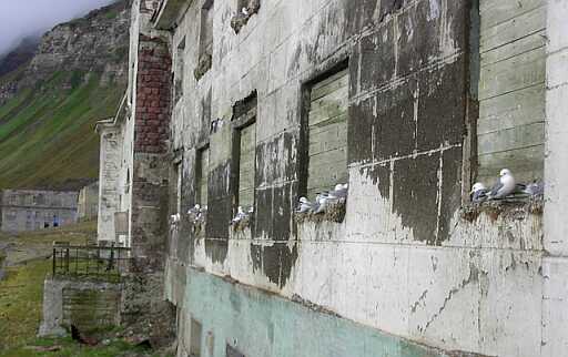
The plan from here is to hike along the beach to Colesbukta. We had a quick check at the first 500-meter, it looked ok, but one has to get the timing right in order not to be caught by high tide. There was also the building on the south side of the river. It looks like it was the staff quarters, it included even a nursery. This building, or at least the sea front has been taken over by the seagulls, every window had some on their nests.
 Irene has decided that she wants to get back to LYB and will follow the beach route to the north. This is a possibility, many hikers are doing this, one just has to be carefull with the tides. The beach is narrow and the cliffs are steep, get caught on the beach by the high tide and you are in trouble.
25-07-2002 (Thursday)
We gave Irene some good advise about the times of the tide. She must start walking at high tide, that was going to be 14h00, that way she would hit the end point at low tide at a point where crossing is the most difficult. And if she gets caught in between she can just sit it out and wait for the water to subside. Jim still tried to convince her to carry on with us, but she is a stubborn German. I think she felt that our style of hiking was a bit unusual for her.
We should have left earlier, fluffing around we only got moving by 10h30, two hours after low tide. It was cutting it a bit fine as we found around the last corner, we just managed by using stepping stones. And just around that corner was a stream cascading down the rocks and five hikers sitting above. This was the place to climb out. Looking ahead I could see that our route along the beach was now flooded. They helped us up and from here it was along higher levels. But first we had to have a wash in this lovely cold stream. Needless to say only the real essentials got washed.
Climbing out of the gorge we found ourselves on a railway track. The book is talking about this, it used to take coal all the way from Grumentdalen to Colesbukta. The Russians have abandoned it, but in such a way that nobody can use the track again. In some places the rails had been bend completely out of shape, at other places we found the rails taken out and neatly stacked and left there.
What was also interesting was that long stretches of the rail were covered by a wooden tunnel, probably to keep the snow off the track in winter. And the biggest surprise was to find a hut, fully intact, next to the track. It was a museum, left there and still maintained by the Russians. With old pictures, documents and showing how people used to live in the area. Most of the writing was in Russian, so we could not make out too much about it. It seemed to be mostly of the Russian exploration of the North. And, I remember, this formed part of their claim they had on Spitsbergen. I presume the Sysselmanen is not too happy having this museum around his patch.
We made use of the living quarters to have our lunch. Who maintains this place? The answer was just around the corner where we came to the remnants of the former settlement of Colesbukta. It's mostly in ruins, but there are a few Russians. Somewhere I read that they are looking at redeveloping the coalfield. They are most likely the people responsible for the museum.
The first big building we came to we identified as a boiler station. Most of the insides have been removed, which includes the boiler. Further on we came to the camping place and another building in good nick, it was flying the Russian flag, the Sysselmannen will not be pleased. The Russians we met there could not speak any English and us no Russian, thus communication was not possible. They showed us some souvenirs, which I presume we were supposed to buy. We didn't, because firstly they were very delicate little constructions and we would have had problems transporting them and secondly, I think, they were kitsch. And they were not selling any beer or coke, so we marched on.
 The last building was the biggest in the village. We dropped our rucksacks to inspect and found another boiler station, much bigger than the previous one.
Leaving the boiler behind us and moving up we came to the local graveyard, with a dozen or so graves. Most of the inscription has weathered away, only one of them was still clearly readable and that was of a young guy who lived from 1930 to 1950.
And the very last structure up the valley was a store housing boxes and boxes of core samples. Somebody had been around here drilling holes. And by the mess they left behind we have to conclude that it was the Russians. It could not have been drilling for coal, because all the drill sites we saw were in the valleys and the coal is up on the mountain. So it must have been for oil and gas.
The last building was the biggest in the village. We dropped our rucksacks to inspect and found another boiler station, much bigger than the previous one.
Leaving the boiler behind us and moving up we came to the local graveyard, with a dozen or so graves. Most of the inscription has weathered away, only one of them was still clearly readable and that was of a young guy who lived from 1930 to 1950.
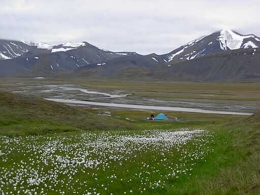
And the very last structure up the valley was a store housing boxes and boxes of core samples. Somebody had been around here drilling holes. And by the mess they left behind we have to conclude that it was the Russians. It could not have been drilling for coal, because all the drill sites we saw were in the valleys and the coal is up on the mountain. So it must have been for oil and gas.
Camp 4 was set up some kilometers beyond that. For a while we were entertained by some nosy reindeers which came over to take a sniff at our trip wires. We didn't like that since this could set off the flares. And talking about these reindeer, they had come from the other side of the valley and when it came to crossing the river they actually had to swim. Which made us think about wanting to initially go further south to Barentsburg. How would we have crossed such a deep river?
next page
return to Norway page
return to home page