31-July-04
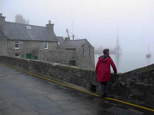 The mist lasted through the night and day. First thing into town to the tourist info place. It's working out well, there is only one bus a day to Northmaven and that one leaves at 17h10. Plenty time to take in the museum and do some shopping. Shopping was done at the Safeway supermarket.
At lunchtime we decided to cash in our free beverage token we had received when booking the campsite. Jim had fish and chips and I some roast pork for £5 each. The free coffee was interesting, one gets a little box and that is pushed into the coffee machine. The coffee wasn't bad.
We had plenty of time left; this was used up by washing some stuff in the campsite washing machine.
The bus ride was pleasant and the weather improving. At the fork to North Roe we were handed over to a smaller bus. The driver took us all the way to her farm, which is the most northerly farm of Northmaven. Inquiring about camping on her farm she just said 'go and enjoy yourself'.
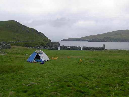
Off we went on a 3km hike to Fedeland. It is the site of an old fishing village. We dropped our rucksacks there; Jim insisted that we first go up to the lighthouse before we put up tent. The lighthouse was not the end; we carried on from there to the most northerly point. It's a lovely coastline, very rugged.
1-Aug-04
 A bright and sunny day, but still it was after 8 before we got up. First thing was playing bowls with the fishnet balls we found laying around here.
Checking out all the old houses was next on the agenda. Some of them had been well build, others not so well. We think we are actually looking at a few generations of houses. The old ones had already been in ruins when the newer ones were constructed. And what was most exciting was finding three boat covers as used by the Vikings. There was also some other round construction which looks very much older than the ruins; we would like to ascribe that to the Vikings as well.
A bright and sunny day, but still it was after 8 before we got up. First thing was playing bowls with the fishnet balls we found laying around here.
Checking out all the old houses was next on the agenda. Some of them had been well build, others not so well. We think we are actually looking at a few generations of houses. The old ones had already been in ruins when the newer ones were constructed. And what was most exciting was finding three boat covers as used by the Vikings. There was also some other round construction which looks very much older than the ruins; we would like to ascribe that to the Vikings as well.
Leaving the tent where it was we took a walk along the coast to get to the sea cave marked on the map. We also had to look for better water, what we had near the campsite was all brackish, not very nice to drink.
At the first beach we came to we found lovely sweet water seeping out of the rock. I had to build a dam to capture it. And than Jim found a stream just next to the beach with good water.
Another stop to watch some seals moving around the clear water just below us.
The sea cave was situated such that we couldn't get to it, couldn't even look into it. Watching the birds and the waves for a while we made our way back.
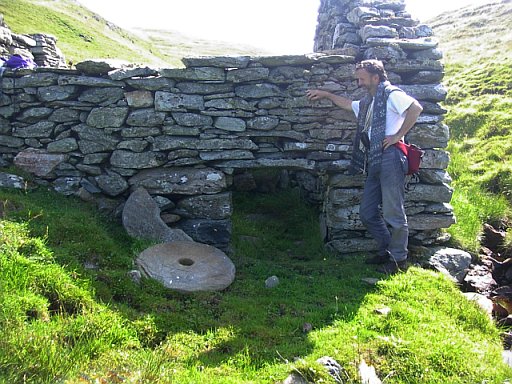 Here we came across another little ruined settlement. This one had a water driven mill. The grinding stones were still there as evidence, but nothing else of the works. And the stream was such a meagre stream, at the most one could get half a Watt from it, how they milled with that is a mystery. And what is also a mystery is what did they grind? I didn't see any fields of wheat, corn, oats etc in the Shetland.
And just as we approached our campsite we saw a shoal (a few) of orcas (killer whales) obviously hunting for something. We noticed them driving something towards the shore. There must have been 5 to 7 of them. A passer by later on told us that they haven't seen orcas in these waters for at least 7 years.
One thing that the Shetlanders seemed to like is rhubarb; we found it growing wild around some of the old houses. Jim thought that this should make a nice pudding. I remember that it was necessary to add a lot of sugar to make it palatable, and that we didn't have in large supply. I cooked the stuff and then threw it away.
The evening was celebrated by having a beach fire using dried seaweed, of which there was plenty laying around. It actually worked and we got a reasonable fire going.
2-Aug-04
We had to break camp and march out, following the road into North Roe. At the farm where the bus dropped us there is a graveyard which we paid a visit to. It was amazing how long people used to live here. Most of them died in their eighties and nineties.
Coming into North Roe and inquiring about the shop we were told it doesn't exist anymore. So no use walking further, taking a right turn we walked away from the settlement to take the path through the peat bogs. Fortunately we had a solid road, thus easy to walk on.
Our aim was to make it to the Neolithic Axe Factory. This was duly found, but no axes. In fact I have my doubts that it was anything at all.
Pushing on the road came to an end in the middle of a sheep kraal and it was cross-country for us. The aim was Long Ayres beach. We were unable to make that because we were driven inland some distance by some high cliffs and bad visibility.
I ran out of steam and we set up camp in a sheltered spot at about 18h00.
3-Aug-04
 The visibility was better and we did want to make it to the beach. Using the GPS we walked into the general direction and came to a point where we could look down onto the beach, but there was no way down. Pushing on we got to a valley with an outlet to the beach.
Dropping our rucksacks we made our way down, near the beach was a water fall and it got a bit tricky, but not for us with umpteen years of mountain experience.
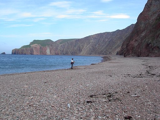
The beach is a reddish colour of sand and stones, well worn and round. Walking along was fun, picking up all sorts of debris from ships. The only useful things found were a pen and a full bottle of iron brew.
And now it was up and over towards the telephone booth shown on the map, which we assumed was also a bus stop. The country here was rough, peat bogs interspersed with grass. At one stage I slipped and fell and soiled my pants once again.
When we hit the road there wasn't much to be done. The bus only comes the next morning. A farmer busy baling nearby was asked for permission to camp. He had no problems and we managed to talk a bit about the business of agriculture.
next---->
return---->
return to home page